Langalibalele Pass Hike


 Old maps may refer to this as "Bushman's River Pass", as it was known in the 19th century. The exact date of the name change to "Langalibalele Pass" is uncertain, but makes reference to the arrest of the amaHlubi Chief Langalibalele at the top of this pass in 1873. Seven people died during this capture, five from the English and two from the amaHlubi, and were buried at the top of the pass. This grave sight can still be visited and is just south of the top of the pass, slightly up the ridge.
This pass is one of the easiest routes to the Drakensberg Escarpment. It tops out between the Sanqebethu and Durnford ridges. With a good path along the entire route and no exceptionally steep sections. This route is suitable for beginners, or fast-and-light day hikers provided they are fit and sufficiently knowledgeable.
Region
Area
Location (Degrees)
-29.279333, 29.436667
Location (Decimal)
29°16'45.6"S 29°26'12.0"E
Type of Hike
Day Hike
Hike Grade
Hike Distance (Km's to destination)
11.0
Total Hike Distance (Km's)
22.0
Hike Duration (to destination)
5.0
Hike Duration (return)
4.0
Total Hike Duration (Hrs)
9.0
Explore
Passes, Vistas
Altitude
2,926
Pass Name
Tags
Directions
Getting There
Giants Castle is fairly easy to access if you have a car. However, there is no public transport that will get you to the offices.
From Durban/Pietermaritzburg (if you are flying in, fly to Pietermaritzburg, if possible): Take the N3 North (signposted as Harrismith/Johannesburg) to the Nottingham Road offramp, turn right at the T-junction above this offramp Follow the road to the town of Nottingham Road (about 15km) Turn right and follow the road through the town, following directions to Rosetta As you reach Rosetta, there is a brown sign on the left to Kamberg, take this road and follow it till it comes to an end at the Giants Castle Offices
From Johannesburg: Take the N3 South (signposted for Durban) Follow the highway till Estcourt, where you will see signs marked "Giants Castle" Follow the signs to Giants Castle and at the end of the road, you will find the Giant's Castle offices.
Route Description
The pass is accessed via the Langalibalele Ridge route from the Giants Castle main offices (not to be confused with the picnic site where one would access Bannerman Ridge). Every turnoff prior to the start of Langalibalele Ridge is sign posted.

Langalibalele Ridge is the hardest part of getting up this route.

Walking up Langalibalele Ridge
The ridge itself is the steepest part of the route, and is a good test for how ready you are for the route. After crossing the contour path, the route climbs a bit further before a gentle downhill traverse to cross the Bushman's River and the start of the pass proper.

The bottom of the pass (left). The Hlubi Passes (centre) and the Thumb (right) can be seen as well.
Once across the river, the steepest part of the trail is reached, although it relents quickly enough - with a side stream crossing, which is well marked by cairns. The pass gradually lessens in gradient and is fairly gentle by the summit - by Drakensberg pass standards, that is.

The steepest section of the pass - notably not difficult by Drakensberg Pass standards.
The easy top half of the pass.
The pass is fairly easy to find from the escarpment, provided you end up in the right valley! The pass is marked by a large cairn on the watershed. The pass tops out at the lowest point on the watershed in the saddle between Bannerman Face and Erskine Peak, just south of the Thumb. The Carbineers' Grave (which is a large pile of rocks with a large metal cross and is visible from a distance) is near the summit of the pass - if in doubt, the graves confirm that you are in the right place.
A common route is to traverse from Bannerman Pass to LangalibalelePass. This route is often attempted by beginners. This is NOT recommended for those who are unfamiliar with the area as crossing the ridge directly south of Bannerman Pass will land you further inland than one might expect, thus making it very easy to get lost. It isn't really feasible to explain this route in words, and therefore photos have been included.

From the top of Bannerman Pass, start by going sharply left to go over the Bannerman/Sanqebethu Ridge.

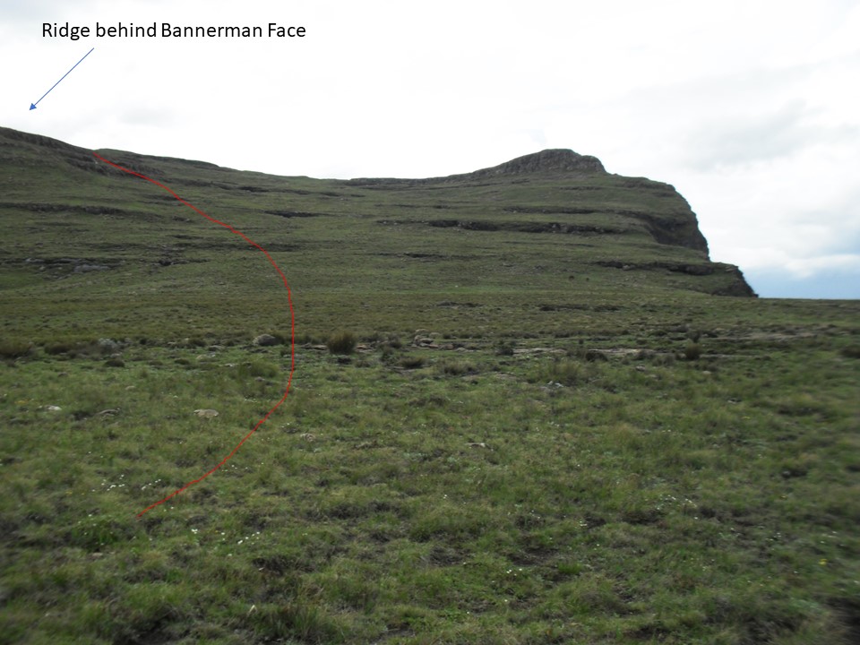
From the top of the ridge, go further left, and cross the ridge behind Bannerman Face.

Follow the river-course down once over this ridge. The Thumb and Giants Castle will be visible in the distance.
The route down from Bannerman Face towards Langalibalele Pass.

The top of the pass is the obvious low point.
It is possible to camp at the bottom of the pass near the contour path, or immediately above the pass, provided you have a suitable 4-season tent. Winds in this region often exceed gale force, and have been known to destroy tents on many occasions. There have also been security concerns above the pass in the past, but no reports in recent years - so caution is advised, e.g. don't leave your boots outside your tent. Bannerman Cave is fairly close to the top of the pass, but is far from water and difficult to find if you don't know where to look.
The route has adequate water in summer, and unless it has been a particularly dry winter, it is usually available in winter as well - although the river does freeze some years.

Pass Looking down the pass from the top, the path is clearly visible.
Essential Gear
Gear depends on the time of year and the year. In winter the rivers are often frozen, and cold gear is essential. If you do this route as a day hike, you can do it with very little gear - but only attempt this if you are very fit and competent, especially with how to survive with limited gear if something goes wrong.
Tracks
| distance | duration | avg. speed | trackpoints | trackpt. distance |
|---|---|---|---|---|
| 10.3 km | n/a | n/a km/h | 270 | 38.25 m |
| altitude range | lowest point | highest point | uphill | downhill |
|---|---|---|---|---|
| 1184 m | 1736 m | 2920 m | 1181 m | 27 m |
