Ship's Prow Pass (South)
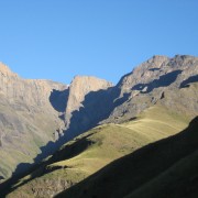
Ship's Prow South Pass is the advised route option, the North Fork has had rockfalls in the past and is very dangerous.
This is a long pass and tops out at 3292m, the highest pass in the Drakensberg.
Listing Details
Region
Area
Location (Degrees)
29°05'58.7"S 29°19'31.4"E
Location (Decimal)
-29.099633, 29.325383
Explore
Passes
Altitude
3,292
Pass Name
Tags
Tracks
GPX track map
Elevation (altitude) diagram of the track
Track length and Trackpoint information
Information | Calculated value |
---|---|
Overall distance (metric) | 4.7 km |
Overall distance (imperial) | 2.9 miles |
Elevation / altitude data (metric)
Information | Calculated value |
---|---|
Altitude range (highest-lowest point) | 1369 m |
Minimum altitude (lowest point) | 1919 m |
Maximum altitude (highest point) | 3288 m |
Uphill (addition of positive altitude changes) | 1376 m |
Downhill (addition of negative altitude changes) | 9 m |
Elevation / altitude data (imperial)
Information | Calculated value |
---|---|
Altitude range (highest-lowest point) | 4491 ft |
Minimum altitude (lowest point) | 6296 ft |
Maximum altitude (highest point) | 10787 ft |
Uphill (addition of positive altitude changes) | 4514 ft |
Downhill (addition of negative altitude changes) | 30 ft |
Map
Reviews (0)