Baboon Rock Hike
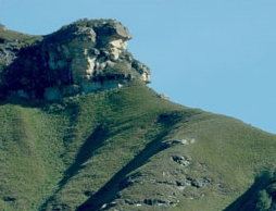
The hike starts at Cathedral Peak Hotel. The hike is 4.1km's to Baboon rock, the last 2 km's on the way to Baboon Rock are fairly steep with a total elevation gain of 440m.
Listing Details
Region
Area
Location (Degrees)
28°55'40.0"S 29°12'21.2"E
Location (Decimal)
-28.927775, 29.205886
Type of Hike
Day Hike
Hike Grade
Hike Distance (Km's to destination)
4.1
Total Hike Distance (Km's)
8.2
Hike Duration (to destination)
2.5
Hike Duration (return)
2.0
Total Hike Duration (Hrs)
4.5
Explore
Vistas
Altitude
1,873
Tracks
GPX track map
Elevation (altitude) diagram of the track
Track length and Trackpoint information
Information | Calculated value |
---|---|
Overall distance (metric) | 4.1 km |
Overall distance (imperial) | 2.5 miles |
Elevation / altitude data (metric)
Information | Calculated value |
---|---|
Altitude range (highest-lowest point) | 465 m |
Minimum altitude (lowest point) | 1413 m |
Maximum altitude (highest point) | 1878 m |
Uphill (addition of positive altitude changes) | 440 m |
Downhill (addition of negative altitude changes) | 57 m |
Elevation / altitude data (imperial)
Information | Calculated value |
---|---|
Altitude range (highest-lowest point) | 1526 ft |
Minimum altitude (lowest point) | 4636 ft |
Maximum altitude (highest point) | 6161 ft |
Uphill (addition of positive altitude changes) | 1444 ft |
Downhill (addition of negative altitude changes) | 187 ft |
Map
Reviews (0)