Centenary Hut Hike
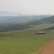
A difficult 10.5km hike starting at Injisuthi Camp to Centenary Hut but worth every aching muscle once you get to the top. The first 7.5 km's are easy and then the "little" hill to climb up to the hut. It seems never ending at times but is most definitely achievable by most people, take it easy up the hill and you will be at the hut in no time at all.
The views are stunning. The hut itself is in a state of disrepair so take along a tent unless you like sleeping in a hut without windows and springs for a mattress.
Listing Details
GPX track map
Elevation (altitude) diagram of the track
Speed diagram of the track
Statistical data extracted from the track file
Track length and Trackpoint information
Information | Calculated value | Placeholder name |
---|---|---|
Overall distance (metrical) | 10.5 km | DISTANCE-KM |
Overall distance (imperial) | 6.5 miles | DISTANCE-MI |
Overall distance (nautical) | 5.7 nautical miles | DISTANCE-NM |
Number of Trackpoints | 427 | TRACKPOINTS |
Average Trackpoint distance (metrical) | 24.51 m | TRACKPOINTDISTANCE-M |
Average Trackpoint distance (imperial) | 80.41 ft | TRACKPOINTDISTANCE-FT |
Times and durations
Information | Calculated value | Placeholder name |
---|---|---|
Start time | n/a | STARTTIME |
End time | n/a | ENDTIME |
Overall duration | n/a | DURATION |
Time in motion | n/a | DURATIONMOVING |
Time paused | n/a | DURATIONPAUSED |
Speeds in metrical units (km/h = kilometres per hour)
Information | Calculated value | Placeholder name |
---|---|---|
Average speed overall | n/a km/h | AVGSPEED-KMH |
Average speed in motion | n/a km/h | AVGSPEEDMOVING-KMH |
Average speed uphill | km/h | AVGSPEEDUP-KMH |
Average speed downhill | km/h | AVGSPEEDDOWN-KMH |
Maximum speed overall | n/a km/h | MAXSPEED-KMH |
Maximum speed uphill | 0 km/h | MAXSPEEDUP-KMH |
Maximum speed downhill | 0 km/h | MAXSPEEDDOWN-KMH |
Speeds in imperial units (mi/h = miles per hour)
Information | Calculated value | Placeholder name |
---|---|---|
Average speed overall | n/a mi/h | AVGSPEED-MPH |
Average speed in motion | n/a mi/h | AVGSPEEDMOVING-MPH |
Average speed uphill | mi/h | AVGSPEEDUP-MPH |
Average speed downhill | mi/h | AVGSPEEDDOWN-MPH |
Maximum speed overall | n/a mi/h | MAXSPEED-MPH |
Maximum speed uphill | 0 mi/h | MAXSPEEDUP-MPH |
Maximum speed downhill | 0 mi/h | MAXSPEEDDOWN-MPH |
Speeds in nautical units (kn = knots = nautical miles per hour)
Information | Calculated value | Placeholder name |
---|---|---|
Average speed overall | n/a kn | AVGSPEED-KN |
Average speed in motion | n/a kn | AVGSPEEDMOVING-KN |
Average speed uphill | kn | AVGSPEEDUP-KN |
Average speed downhill | kn | AVGSPEEDDOWN-KN |
Maximum speed overall | n/a kn | MAXSPEED-KN |
Maximum speed uphill | 0 kn | MAXSPEEDUP-KN |
Maximum speed downhill | 0 kn | MAXSPEEDDOWN-KN |
Elevation / altitude data (metrical)
Information | Calculated value | Placeholder name |
---|---|---|
Altitude range (highest-lowest point) | 847 m | ELE-DELTA-M |
Minimum altitude (lowest point) | 1453 m | ELE-MIN-M |
Maximum altitude (highest point) | 2300 m | ELE-MAX-M |
Uphill (addition of positive altitude changes) | 893 m | ELE-UP-M |
Downhill (addition of negative altitude changes) | 62 m | ELE-DOWN-M |
Elevation / altitude data (imperial)
Information | Calculated value | Placeholder name |
---|---|---|
Altitude range (highest-lowest point) | 2779 ft | ELE-DELTA-FT |
Minimum altitude (lowest point) | 4767 ft | ELE-MIN-FT |
Maximum altitude (highest point) | 7546 ft | ELE-MAX-FT |
Uphill (addition of positive altitude changes) | 2930 ft | ELE-UP-FT |
Downhill (addition of negative altitude changes) | 203 ft | ELE-DOWN-FT |