Garden Castle to Rhino Peak (Thaba Ngcobo)


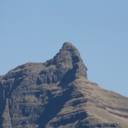

An difficult 10km hike to Rhino Peak which takes roughly 5 hours with a total uphill of 1 194m. An early start and the hike to the top and back can be done in a day, else take is easy and sleep in a cave or tent at the top overnight.
Listing Details
Area
Location (Degrees)
29°42'45.9"S 29°10'17.6"E
Location (Decimal)
-29.712761, 29.171550
Type of Hike
Day Hike, Overnight
Hike Grade
Total Hike Distance (Km's)
20.0
Hike Duration (return)
4.0
Total Hike Duration (Hrs)
9.0
Explore
Peaks
Altitude
3,051
Tags
Tracks
GPS Track Details
| Track length: | 10.03 km |
| Total ascent: | 1236 m |
| Total descent: | 59 m |
Video
Map
Reviews (1)
 by
Michael Arnold
by
Michael Arnold
Good challenge
Great walk with a bit of everything.