Halfway/Slab Cave (Fisherman's Cave) Hike


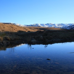


A great day hike that's easy and suitable for younger children. As you walk along the Bushman's Nek River and deeper into the valley you will get a great feeling of being outdoors.
Some of the gallery pictures show the area when it had snowed. The snow was 3 foot deep near Halfway/Slab cave and no path could be found, another reason for having a map when hiking in the Drakensberg.
Listing Details
29°49'11.2"S 29°10'27.2"E
-29.819778, 29.174222
The route starting at the Bushman's Nek Office where you fill in the mountain register passes the South African border post. You then cross the stream twice and turn right (if you go straight you are heading towards Tarn Cave and would cross the stream a third time) thus walking with Bushmans River on your right. To your right on the other side of the river you will see Bushman's Nek Hut as you walk along a slightly upward path
Over the 5km's you will cross the Bushman's river 3 times, the 3rd time 180m from the cave which will be above you and slightly to your right.
| Track length: | 5.12 km |
| Total ascent: | 166 m |
| Total descent: | 11 m |