Marble Baths Hike Popular


From Injisuthi Camp follow the route towards Fergy's Cave, after 5km's turn right crossing over the river, only 3km's and 200m elevation to go. The path is on the left side of the valley and slowly climbs higher towards Marble Baths.
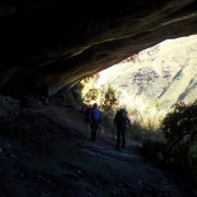
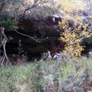
Marble Baths Cave and Annex are 50m from Marble Baths should you choose to sleep overnight, its well worth it the caves offer a level floor and good protection from the elements.
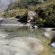
Marble Baths themselves are beautiful, enjoy a swim and the natural super tube, kids and adults will enjoy it.
The cave is booked by contacting the Injisuthi Reserve on +27 (0)36 431 9000 or can be booked online here. The cave can sleep 8 and has a raised platform to keep you away from the elements. You will want to book ahead of time to sleep here because it is a very popular cave in the Drakensberg.
There are a few hard uphill sections and but nothing to serious and two river crossings, please be safe when crossing the river and do not attempt the river crossings when it is in flood.
Other hikes to consider are The Sphinx Hike at the Monks Cowl Nature Reserve and the Chain Ladders to the the highest waterfall in the world.
Listing Details
29°09'03.6"S 29°23'51.8"E
-29.151000, 29.397717
| Track length: | 7.83 km |
| Total ascent: | 449 m |
| Total descent: | 89 m |