

About Drakensberg Hikes
Drakensberg Hikes is an independent community portal providing verified trail reports, sleeping cave logs, GPX tracks, and accommodation directories for the Maloti-Drakensberg World Heritage Site.
When I was a child, we used to go to the Northern Drakensberg every couple of months. My parents would attend meetings and work-related activities, and my sibling and I would roam around the resort. We played volleyball, rode horses, took the quad bikes for a spin and went on hikes.
This is where my love affair with hiking started…
As Ryan’s birthday is on a public holiday (Freedom Day), which happened to fall on a Friday this year, I decided to take Ryan to the Drakensberg for a birthday weekend getaway.
I started researching hikes in the Royal Natal National Park and was amazed to find out that the Tugela Falls (one of the world’s highest waterfalls) is within the park. I also discovered that the hike to the Tugela Gorge is one of the longest hikes in the park and is considered one of South Africa’s best one-day hikes.

The drive from Johannesburg to the Mont Aux Sources Hotel is approximately 3 hours and 45 minutes. The road passes by beautiful landscapes and through the historic town of Harrismith before reaching the Sterkfontein Dam and turning onto the mountain pass that eventually reaches the Mont Aux Sources Hotel.
We arrived at the hotel close to sunset and were met with a troop of baboons grazing the field right outside our chalet. We decided to get an “early” night so that we could be up bright and early for our hike to the Gorge.

View from our Chalet at the Mont Aux Sources Hotel
As holidays go, our “early” start didn’t end up being so early. The Royal Natal National Park is about a 1 kilometre drive from the hotel. We arrived at the gate of the Royal Natal National Park at about 10 AM.
To get to the start of the trail, we paid the entrance fee into the Park and drove to the parking lot of Thendele Camp. At the parking lot there is a big board with a map showing all the trails in the Park. The start of the hike is marked with a sign and the trail is clearly defined.
The hike follows a path along the side of the mountain next to the river all the way to the Gorge – this same path is followed back to the starting point of the trail. Even though the hike is about 17 kilometres in total, it’s not strenuous but relatively flat all the way. The only thing that makes this hike a bit tough is the distance.

On the day we hiked, the weather was pleasant – not cold and not scorching hot. Perfect Autumn hiking weather. The only downside to the hike was how busy the trail was! EVERYONE decided to make use of the long weekend to go on a short holiday… a number of school camps, families, children, grandparents. No one was deterred from hiking this trail.
About a kilometre after the start of the trail, there is a bridge that needs to be crossed. Shortly after that, the eroded sandstone pillar known as Policeman’s Helmet is in sight. Carry on walking along the path, which takes hikers in and out of lush forests and protea bushes. After about 6 kilometres, the trail takes you right into the riverbed of the Tugela, where you walk along the river for a couple of kilometres until you reach the Gorge.

This last end stretch before the Gorge is absolutely stunning with views of the bright and blue rock pools. This account describes the gorge and chain-ladder options encountered on that trip. Confirm current access and conditions with the reserve before entering the gorge or using the ladder. Do not enter the gorge in flood or attempt to cross swollen or fast-flowing water; turn back if conditions are unsafe.
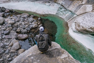

We decided to attempt the walk through the end of the gorge (the water was FREEZING). We turned around after reaching the bit where you have to use all your strength to scurry up over the rock wall to climb out of the gorge. At this point, we were tired, hungry and cold. We found a spot to devour our packed lunch and decided to make our way back to Thendele Camp.
 The hike took us about 4 and a half hours in total, which included our lunch time.
I’ve done a number of hikes and this has been one of my favourite trails. The hike is flat but long. Around every bend is a new landscape with more incredible scenes. Besides the amount of people on the trail that day, you feel as if you are in the middle of nowhere. Simply nature and yourself.
If you are a hiking enthusiast, I highly recommend that you put this trail on your bucket list!
What to take:
- Walking shoes – proper walking shoes have better grip and help to prevent injuries sustained by slipping and falling.
- Water
- Food
- Sunblock
- Camera – you would not want to miss an opportunity to take some picturesque photos.
- Cellphone – always take a cellphone with you in case of an emergency.
xxx Ingrid (Grace & Gaia) - https://graceandgaia.com
⚠️ Mountain Safety Notice
Weather conditions in the Drakensberg escarpment can change within minutes. Always register your group in the official Ezemvelo Mountain Rescue Register before starting any overnight trail, carry gear for extreme cold/rain, and ensure you have verified offline GPS tracks.
Download Rescue Form (PDF)More Mountain Stories & Route Reports

Nine Caves in three days

Organ Pipes Pass - Thuthumi Ridge Route

Mzimkulu Vulture Hide, Southern Drakensberg to Launch in aid of Endangered Vulture Conservation

How to plan an overnight hike in the Drakensberg mountains

Drakensberg Trek: Rolands Cave
